 9ura00
How to use ToVue — Explore 3D maps and capture the view
ToVue lets you fly around 3D maps on iPhone and iPad with drone-style controls. Explore cities from above and save your favorite views as photos and videos.
It does not request location permission or use GPS. This is a way to explore a map from the sky, not an app for controlling a real drone.
Try one short flight and one photo first
- Open the menu at the top right and search for a city. The example below shows Manhattan, New York.
- Wait for the map to load. Move the left stick slightly upward to change altitude, then the right stick upward to move forward. Release the stick to stop.
- Adjust the 3D/2D slider on the right until the buildings are easy to see.
- Select Photo, press the shutter, and inspect the preview.
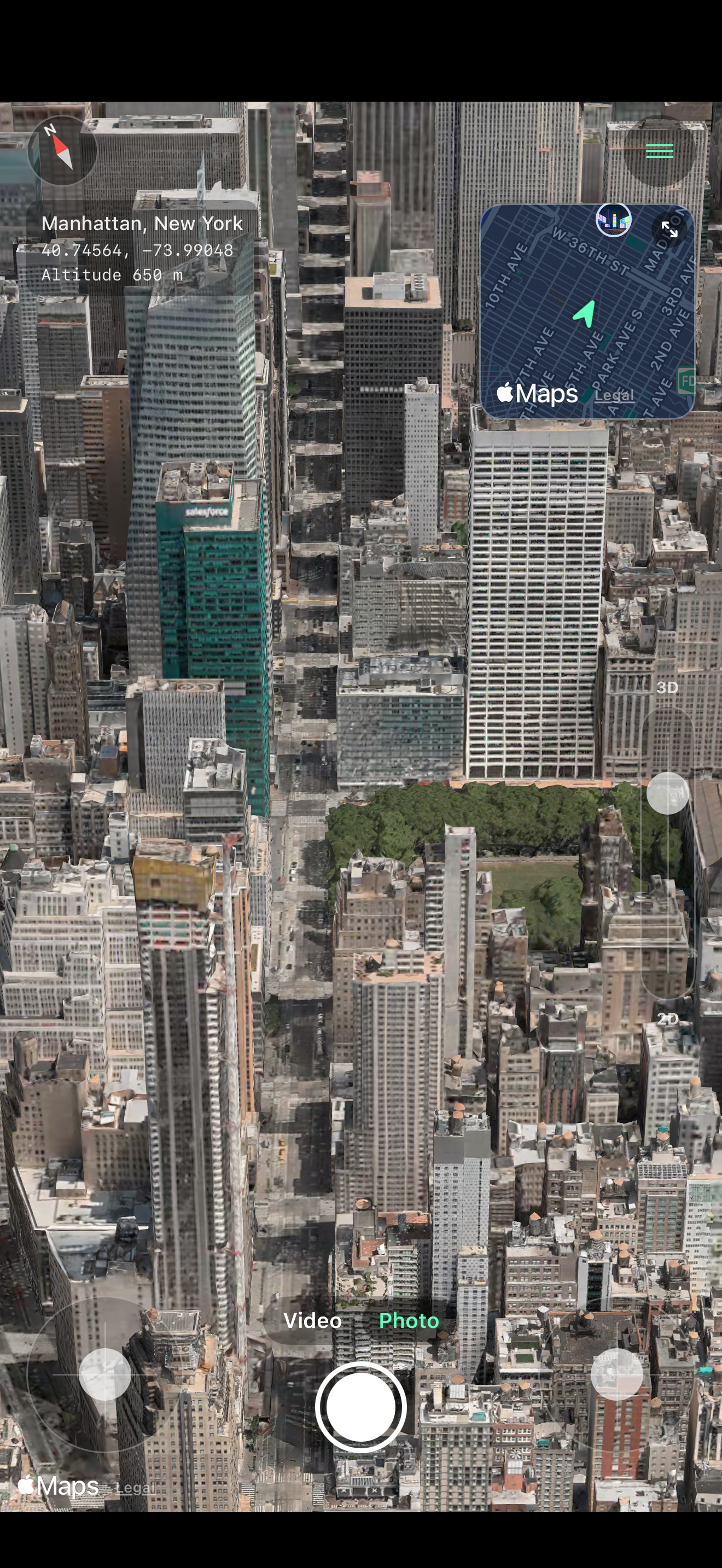
This screenshot was captured from the app for App Store materials. The place and coordinates identify the map view, not the device’s GPS location. The sticks and shutter are at the bottom; the mini map is at the upper right. Map detail depends on the area and loading state, so your view may differ.
Fly with two sticks
The two sticks at the bottom of the screen use a layout commonly called Mode 2 on drone controllers.
| Stick | Move up or down | Move left or right |
|---|---|---|
| Left | Ascend or descend | Turn |
| Right | Move forward or backward | Move sideways |
The farther you move a stick, the faster you move. Release it to stop.
One-hand mode
In the menu, open the controls settings and turn on One-Hand Mode. There is now one stick: touch it to move forward, move it up or down to ascend or descend, and move it left or right to turn.
Choose a destination
You can start exploring from a place you choose.
- Search: Use the place search option in the menu to find a city, landmark, or building.
- Choose on the map: Use the map selection option in the menu, then tap a destination.
- Mini map: The mini map at the top right shows your position and direction. Tap it to choose a destination on the map.
The initial starting point is based on your device’s Region setting.
Adjust the 3D angle
The 3D/2D slider on the right changes the camera angle. Move it up to look toward the horizon, or down to look straight at the ground. This is like tilting the view with two fingers in a map app.
You can also hide the slider from the menu.
Take a photo
Choose Photo above the shutter button, then press the shutter. Turn off the options to include controls if you want a map-only image.
In the menu’s photo and video settings, you can choose whether to include:
- The place name, coordinates, and altitude.
- The sticks, mini map, and 3D slider, if you want to show the controls.
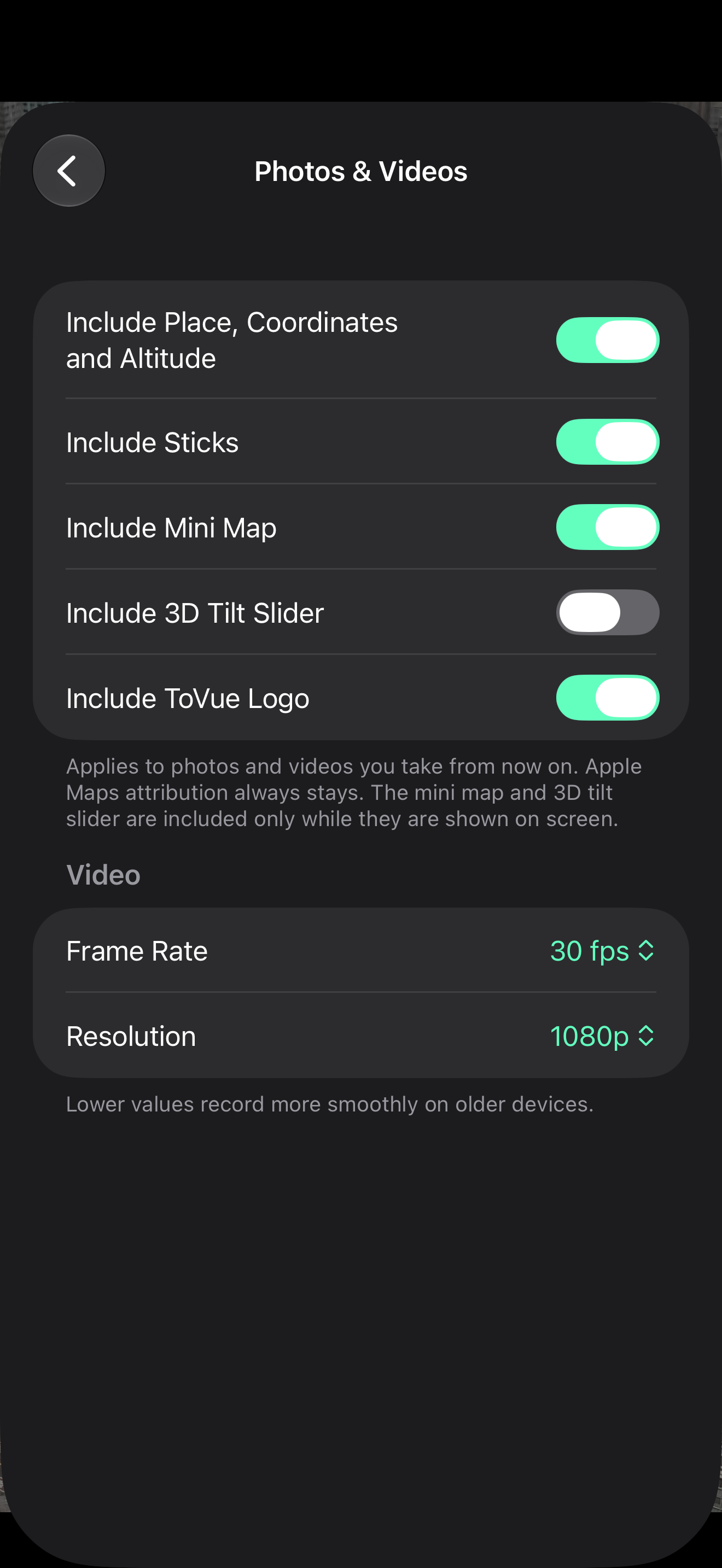
In this screenshot, Include Sticks and Include Mini Map are on. For a map-only capture, turn those off along with Include 3D Tilt Slider before taking the shot. These settings apply to new captures; they do not change files you already saved. Apple Maps attribution remains.
Record a video
Choose Video above the shutter button and press it to start recording. Press it again to stop, then save or share from the preview. Recordings can be up to five minutes long. Try a short clip first, then check the motion and included overlays in the preview before saving.
If the video stutters, lower the frame rate or resolution in the photo and video settings.
Ads and the ToVue logo
The free version displays ads and adds a small ToVue logo to the corner of photos and videos.
The Remove Ads & ToVue Logo one-time purchase removes ads and lets you turn off the ToVue logo in the photo and video settings. It is not a subscription. On another device signed in to the same Apple Account, use the menu’s restore purchases option.
Check the App Store purchase confirmation for the price offered in your storefront.
Apple Maps attribution always remains in photos and videos to identify the map data provider.
Source of this guide
The steps were checked against the app implementation and screenshot tests saved as of October 16, 2026. The images are saved captures of the app. Their exact app and OS versions cannot be established from the images alone, so no capture-version number is claimed. See official support if your installed version looks different.
Common questions
- Why are the map or 3D buildings missing? An internet connection is required. 3D buildings and aerial imagery come from Apple Maps, and the level of detail varies by area.
- How do I delete the app’s data? ToVue stores settings on the device. Deleting the app removes those settings. Photos and videos you saved to the Photos app remain there.